Indian peninsular plteau
India: Peninsular Plateau India: Peninsular Plat
This sixteen million square km It is a very ancient landmass spread in This triangular shape is surrounded by the Ganges-Sutlej plain in the north and the sea in the remaining three directions. It is the largest physical region of the country. The peninsular plateau region is a part of Gondwana land. There are many mountains located on this plateau, which are completely affected by millions of years of weather. These mountains are divided into many small plateaus. It also has narrow and wide river valleys. Thus it is replete with many surface variations.
The average elevation of these plateaus is about 600 meters above sea level. They extend from Rajasthan in the north to Kanyakumari Antarip in the south, 1,700 km. 1,400 km in length and Is up to a width of Under these areas are the plots of several states - Madhya Pradesh, southeastern Rajasthan, Dakshin Vihar, Maharashtra, Odisha, Gujarat, Andhra Pradesh, Tamil Nadu, Karnataka, Kerala etc. Naturally, its northern boundary is formed by the Aravalli, Kaimur and Rajmahal hills. It is bounded by the Eastern Ghats in the east and the Western Ghats in the west. Although several views have been presented by scholars from time to time regarding its extent, but it has also been confirmed on the basis of these new studies that this plateau was widely spread before the creation of the Himalayan mountain range. Was. These plateaus have affected the Himalayan turns. The Himalayas appear to be facing south due to the north-west and north-east direction of the plateau. This plateau is severed from many places and is divided into many small plateaus and hills. Therefore, it becomes extremely necessary to study in detail with respect to this plateau.

Narmada, Sone, etc. have been divided into many small plateaus of this plateau by several rivers. To the north of the Narmada lies the Malwa plateau and to the south is the Deccan plateau. To the east of the Son River lies the Chotanagpur plateau. Apart from this, these plateaus are found near various rivers.
[table id = 2 /]
Deccan Plateau
It is the largest plateau in India. The Deccan plateau is triangular and extends over 7,005,000 sq km. Is in the area. It is 3000 meters high in the north and 900 meters in the west. It is also called Maharashtra Plateau. This plateau covers the territory of the states of Maharashtra, Madhya Pradesh, Karnataka, Gujarat and Andhra Pradesh. Its northern boundary forms the Tapti River and to the west the Western Ghats. This plateau is made up of basalt rocks. These rocks have abundance of minerals and minerals like iron, mica, magnesite and bauxite are found. It is divided into two parts by the Godavari river - the Telangana plateau and; Karnataka Plateau.
The Telangana plateau is a forested plateau in the northern part of the Godavari River. The Wardha River flows here on the southern part is the Urmil plain, on which there is suitable land for making ponds for irrigation. Its lower part is flat, in which big cities are found. Hyderabad and Secunderabad are prime examples.
The Karnataka plateau with an altitude of 600 meters divides the two lines - the northern part and the southern part. The Krishna and Tungabhadra rivers flow over the northern part. Here the rivers Ghat-Prabha and Mal-Prabha meet on its right side in the Krishna River. The southern part of the Karnataka plateau is called the Mysore Plateau. It is a high-altitude plateau of South India. Generally, the slope is towards east, while the northern part is facing north. To its west lie the Western Ghats and to the east the Eastern Ghats. Its southern boundary is formed by the Nilgiri hills. The western part is known as Malwar, which is a mountainous region. Its average elevation is 1000 meters. There is considerable erosion in this mountainous region. The slope is quite sharp and the river valleys are deep. This part is completely covered with forests. The east side is covered with Urmil plains. The main river of the Mysore plateau is the Kaveri. Granite hills are found here, which are sunk below.
Malwa Plateau: This plateau is a black clay plateau formed by lava. Its slope is towards the Ganges valley. In this, rivers like Parvati, Betwa, Mahi, Chambal and Kali Sindh flow into the Yamuna.
On average, on these plateaus, 250 meters high, Urmil plains are found somewhere in which flat hills are also located. For example, Gwalior hills are prominent in the north. The plateau of Bundelkhand and Baghelkhand are located on the northern and north-eastern border of this plateau, but the north hemp of the plateau has been converted into rugged Khadu by Chambal and its tributaries.
Chotanagpur Plateau
This plateau is spread in Gaya, Hazaribagh and Ranchi etc. areas of Bihar and Jharkhand. It has an average elevation of 700 meters. Mahanadi, Swarna Rekha, Son and Damodar etc. are the main rivers of this plateau, which flow in deep valleys and spread in different directions. The Son River flows from the northwest of the plateau and merges into the Ganges River. The Damodar River flows from west to east in the central part of the plateau. The Mahanadi is its southern boundary, which flows to the southeast. The northern boundary of this plateau is the Rajmahal hills. Chotanagpur plateau is divided into several parts. To the north of the Damodar River, there are several plateaus and clusters of hills, of which the plateaus of Hazaribagh and Koderma are prominent. To the south of the Damodar River lies the Ranchi Plateau. The Ranchi plateau is generally flat, except for some low hills, where granite and nice rocks are found here. The city of Ranchi is situated on this flat part. Rivers flow from this city in all four directions. The Damodar Valley is now available as a fault, with deposits from the Gondwana period. This plateau can be considered very rich in terms of minerals. Major minerals of India are bauxite, mica and coal etc. found here. Apart from this, tungsten, chromite, limestone, clay, quartz, timber, copper etc. are also available in abundance here. This plateau has special significance in terms of forest wealth. Here teak, rosewood, sal, berries, semal and bamboo etc. are also found in abundance. Rice is cultivated in food grains in hill slopes and river valleys.
Meghalaya Plateau: It is formed from the deposits of Gondwana period. The northern slope of the Meghalaya plateau is perpendicular from where the Brahmaputra River flows and the southern slope is slow.
Bundelkhand Plateau: This plateau is spread between Gwalior plateau and Vindhyachal range. Its elevation is between 300-600 meters. It is also called the plateau of Baghelkhand.
The oldest Bundelkhand is made from Nees and Sopani altars are also found on it. Granite and sandstone mounds and hills are also found around it.
The plateau of Baghelkhand lies east of the Kaimur and Bharner hills of the Vindhyan range. To its north are the Sonepur hills and to the south are the Ramgarh hills. The central part of Baghelkhand has progressively increased from east to west. Here sandstone and limestone are found in the western part and granite rocks in the eastern part.
The peninsular plateau's mountain ranges
The mountain ranges of the peninsular plateau can be classified as follows-
Vindhyachal: The extension of the Vindhyachal range is in disorganized form. It starts westward along the Narmada River, starting from Gujarat and moving in a northeast parallel to the north-east direction and eventually extends its extension to Mirzapur in Uttar Pradesh. The Vindhyachal ranges are a composite form of the hills of Vindhyachal, Bharner, Kaimur and Parasnath. Flaky rocks (consisting of red and sandstone) are found in the Vindhyachal mountain. The Vindhyachal mountain itself clearly distinguishes northern and south India from each other. The average elevation of this mountain is 900 meters.
Satpura: This range extends from the hills of Rajpipla in the west between the rivers Narmada and Tapti to the plateau of Chotanagpur. Mahadev and Maikal hills are also under the Satpura ranges. The geographical spread of the Satpura ranges lies between 21 ° to 24 ° northern latitude and has an average elevation of 760 meters. 1350 meters high Dhupgarh peak is the highest peak of Satpura. This peak is situated on the Mahadev hill. The Narmada River originates from the Amarkantak peak (1,066 m) of Satpura. The Dhupadhar waterfall is most famous near Jabalpur under the Satpura ranges. Marble rocks are obtained from Satpura.
Aravali: The Aravalli mountain range extends from the eastern boundary of the desert of Rajasthan near Ahmedabad to the south-west of Delhi in the north-east. The total length of the Aravalli ranges is about 880 kilometers. Gurshikhar (1,772 m) near Abu is the highest peak in Aravalli. The average elevation of Aravali is between 300 and 900 meters. The Aravalli Range acts as a water divider. On its west side are the rivers Mahi and Luni, which fall into the Arabian Sea. The Banas River originates on the east side, which acts as a tributary of Chambal. All these rivers are temporary (seasonal).
Western Ghats or Sahyadris
The Western Ghats extend parallel to the western coast from the western boundary of the Deccan plateau. It is 1,600 km from Tapti river valley in north to Kanyakumari in south. Is detailed in length. In terms of geographical structure, the Western Ghats are divided into three classes -
Northern Sahyadri
Middle Sahyadri
Dakshin Sahyadri
Northern Sahyadri: Starting from the Tapti River, it is 650 km in length from the origin of the Malprabha River. The average elevation of northern Sahyadris is 550 meters. The Godavari, Bhima, Krishna and Urra rivers originate from here. Kalasubai (1,646 m), Salher (1,567 m) and Mahabaleshwar (1,438 m) are the major peaks of northern Sahyadri. Thalghat (581 m) and Bhorghat (680 m) are the two main passes of northern Sahyadri. The route from Mumbai to Kolkata is via the Borghat Pass.
Madhya Sahyadri: It is 650 km in length from the origin of the Malprabha River to the Palghat Pass. This area is quite rugged and covered with forests. The average elevation of the middle Sahyadri is 1,220 meters. Kudremukh (1,892 m) and Pushpagiri (1,794 m) are the major peaks here. The rocks of the Middle Sahyadri are of granite and fine type. On its east side, the rivers Tungabhadra and Kaveri are the period.
The South Sahyadri is 290 kilometers in length from the Nilgiri Hills to Kanyakumari. There are Nilgiri hills as well as Annamalai hills in this part. Annaimudi (2,695 m) is the highest peak in southern Sahyadri. To the north-east of the southern Sahyadri are the hills of Palani and to the south are the cardamom hills.
Eastern Ghats: The Eastern Ghats extend over a length of 1,300 kilometers from the Mahanadi to the Nilgiri Hills. The average height of the Eastern Ghats is 615 meters. The hills from south to north under the Eastern Ghats are known as Nilgiti, Palkonda, Annamalai, Javada and Shivarai hills. The level of the Eastern Ghats has remained the same between the delta of the Godavari and Krishna rivers. Visakhapatnam (1,680 m) is the highest point in the Eastern Ghats and is followed by Mahendragiri (1,501 m). The Eastern Ghats are formed from the rocks of Charconites and Khondalites. Sandalwood forests are also found in the Eastern Ghats. The Hojekal Falls, formed by the Kaveri River, is in the Eastern Ghats.
[table id = 1 /]
The peninsular plots are geologically very rich and many types of metallic and non-metallic minerals are found here. The largest fraction of minerals is found in the Chotanagpur plateau.
Importance of Peninsular Plateau of Peninsular Plateau
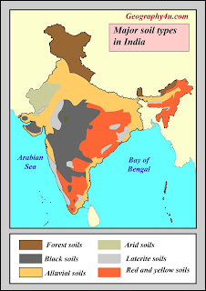
The black soil from the basalt rocks of the peninsula is extremely beneficial for cotton and sugarcane crops. The peninsula topography is also considered favorable for the production of hydroelectric power, as most of the peninsular rivers form numerous falls in their flow paths. But due to the seasonal nature of these rivers, the capacity of hydropower generation becomes quite limited.
The Vindhya hills act as a natural water divide between north and south India, as a result of which the people of the land south of Vindhyachal have developed their distinct cultural identity (including regional differences).

Comments
Post a Comment